Fetch georeferenced occurrence records from the Global Biodiversity Information Facility straight onto the GeoLibre map.
Coba langsung: GeoLibre (Qiusheng Wu) berjalan di halaman ini. Buka Plugins → Marketplace, pasang GBIF Data, atau buka layar penuh.







Fetch georeferenced occurrence records from the Global Biodiversity Information Facility straight onto the GeoLibre map.
Independent project. This is a community plugin, made out of appreciation for GBIF’s open data. It is not made, affiliated with, sponsored or endorsed by GBIF. “GBIF” names the data source only; the plugin uses no GBIF logo. The data belong to their publishers and come with no guarantee of quality or completeness — see the GBIF data user agreement.
Ringkasan (Bahasa Indonesia) — Plugin GeoLibre untuk mengambil data kemunculan (occurrence) spesies dari GBIF langsung ke peta. Filter berdasarkan area (tampilan peta, extent layer, negara, atau seluruh dunia), takson, jenis rekaman, tahun, kualitas data, kategori IUCN, dan lainnya. Hasil bisa ditambahkan sebagai titik (GeoJSON, maks. 5.000 rekaman), sebagai layer kepadatan heksagon GBIF, atau keduanya. Klik titik untuk melihat detail dan foto rekaman. Plugin ini dibuat secara independen sebagai bentuk apresiasi, bukan produk resmi GBIF. Kartu “Cite this data” membantu mengutip data sesuai pedoman GBIF (daftar dataset untuk DOI derived dataset).
Screenshots
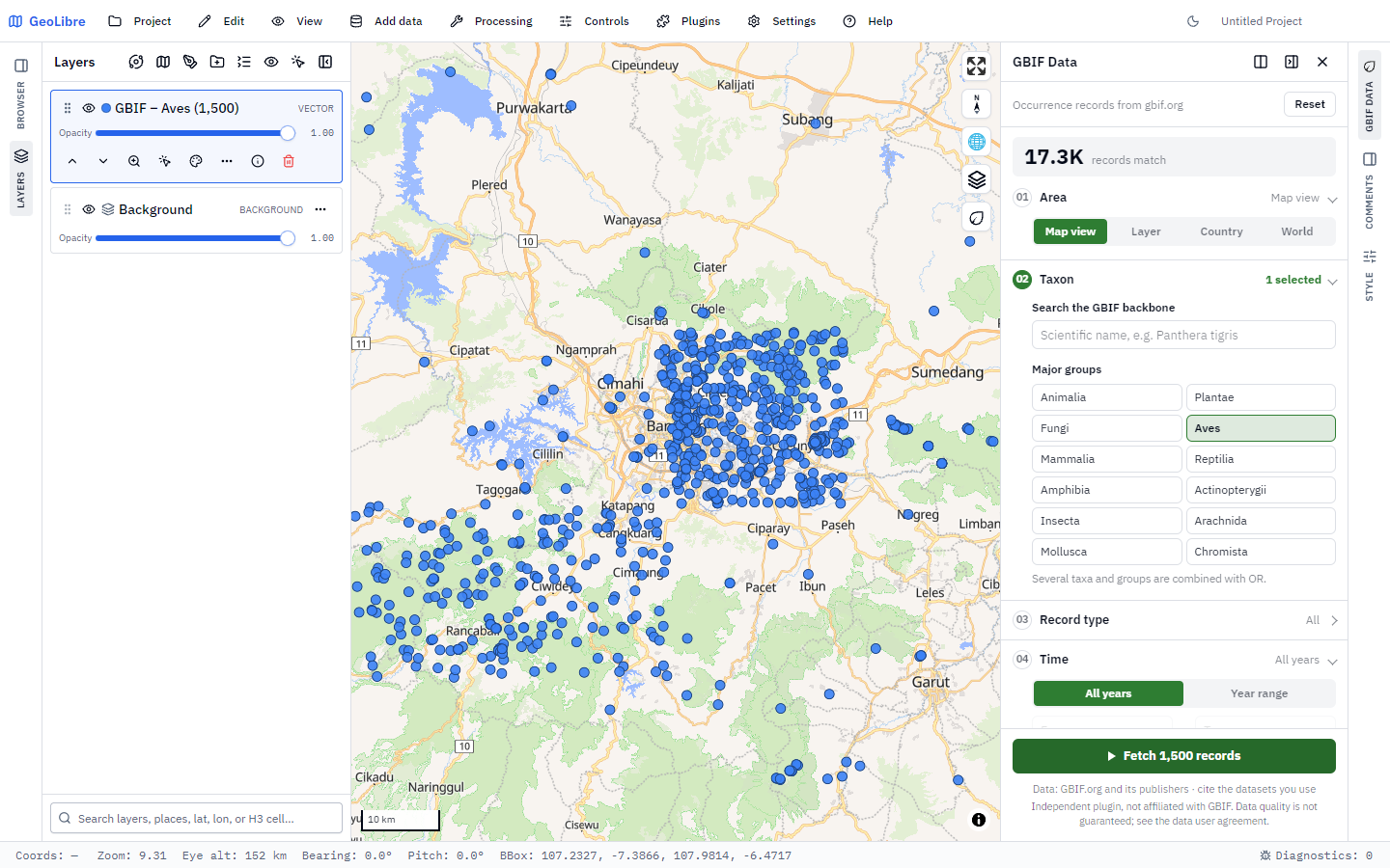 1,500 bird records around Bandung, West Java, added as a point layer. The
header counts every matching record in GBIF (17.3K); the numbered steps hold
the filters.
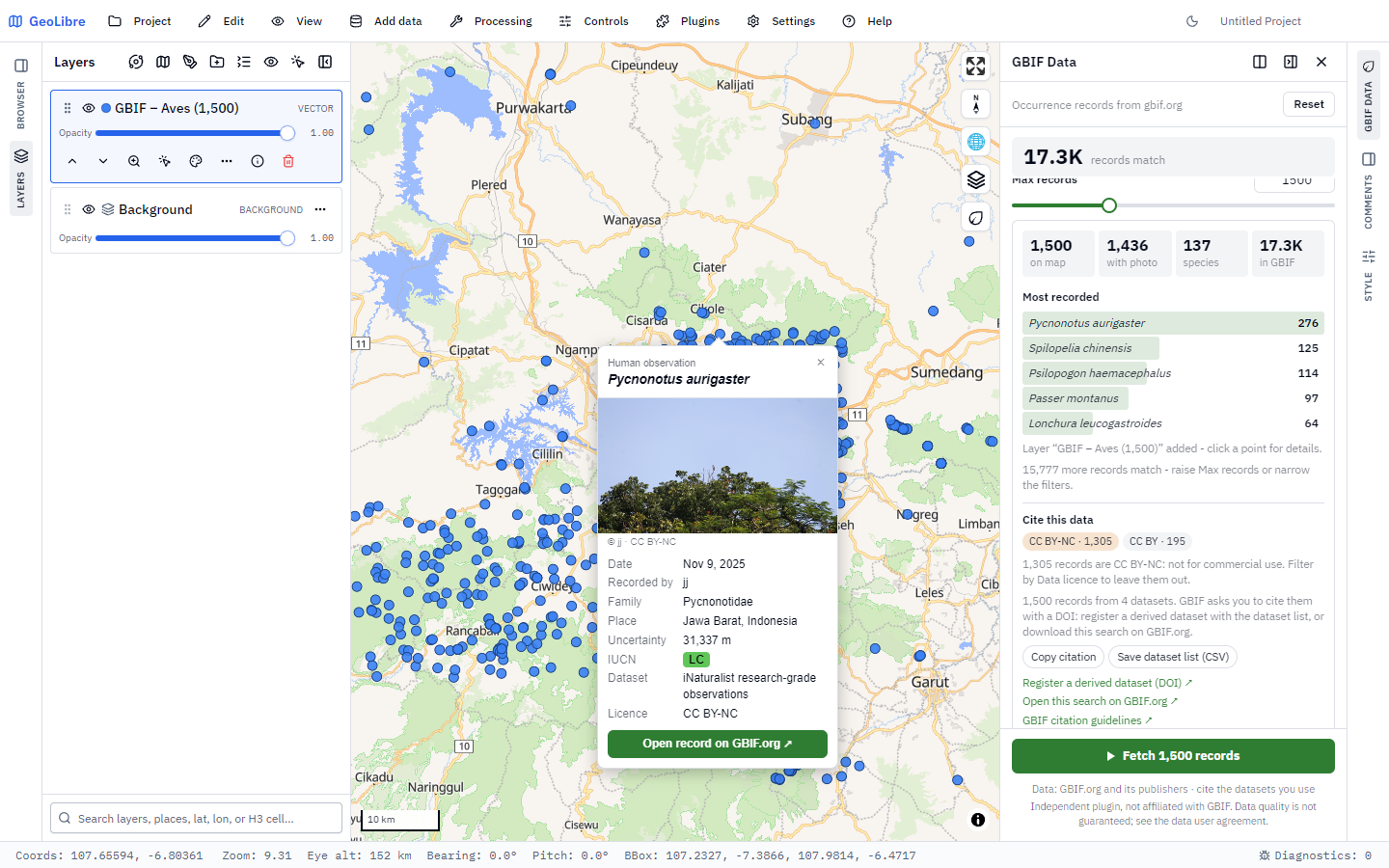 Clicking a point opens its record: photo with creator and licence, date,
recorder, family, place, uncertainty, IUCN category, dataset and licence. The
results card lists the most recorded species, and Cite this data shows the
licence mix (with a CC BY-NC warning) and the citation tools.
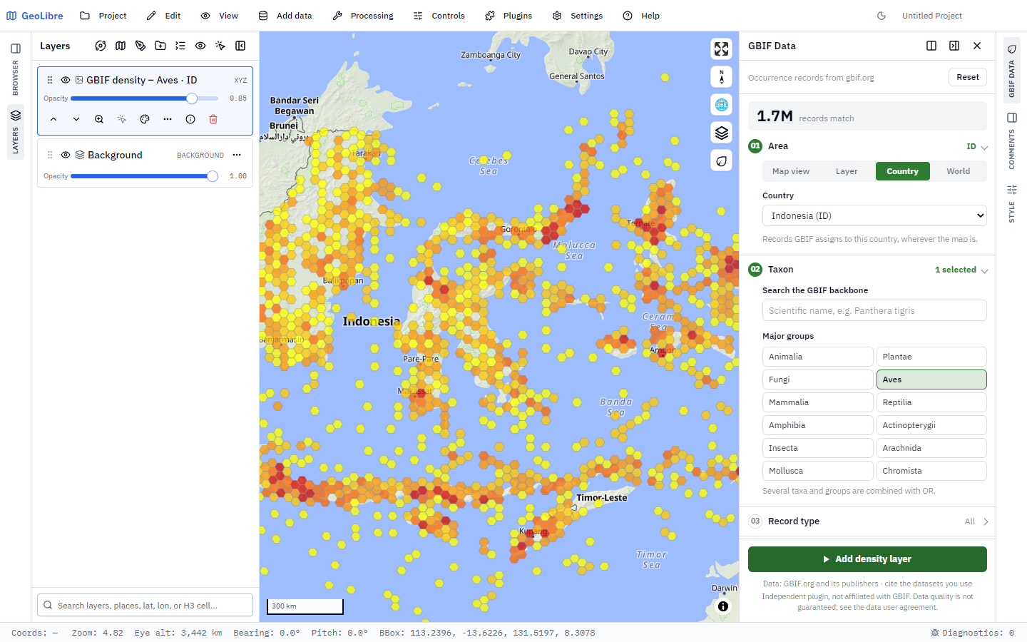 Density output for Area = Country (Indonesia): GBIF hexagon tiles of all 1.7
million matching bird records, without downloading them one by one.
Contents
Features
Live counter — the header shows how many GBIF records match the current filters (a
limit=0request), and follows the map while the area is the map view.01 Area — map view, extent of a layer, a country (ISO code), or the whole world (only together with a narrowing filter).
02 Taxon — search the GBIF backbone with suggestions (
species/suggest, Enter falls back tospecies/match), pick several taxa, and/or one-click major groups (Animalia, Plantae, Fungi, Aves, Mammalia, ...). Everything selected is combined with OR.03 Record type — basis of record (human observation, preserved specimen, machine observation, ...).
04 Time — all years or a year range, with presets.
05 Quality — photos only, drop geospatial issues, presence records only, maximum coordinate uncertainty, IUCN Red List category, data licence (CC0, CC BY, CC BY-NC).
06 More filters — recorded by, dataset key, institution code, keyword.
Add to map as points (GeoJSON, up to 5,000 records), as GBIF hexagon density tiles (every matching record, via the ad-hoc map API), or both.
Results card — records added, records with a photo, species count, total in GBIF, and the five most recorded species.
Cite this data — licence breakdown of the fetched records (with a warning for CC BY-NC), Copy citation, Save dataset list (CSV) for registering a derived dataset with a DOI, and a link to the same search on GBIF.org for a DOI-backed download. See Data use and citation.
Popup — click a point for its name, date, recorder, family, place, coordinate uncertainty, IUCN category, dataset (linked to its GBIF page), record licence and photo with its creator and licence, plus a link to the record on GBIF.org. The popup stays inside the map near the edges.
Active filter tags — every filter in use shows as a removable chip above the Fetch button; Reset clears them all at once.
Polite to the API — pages of 300 with a pause between them, a 5,000 record cap, and automatic back-off when GBIF answers 429 / 503.
No API key, no dependencies — a single self-contained ES module that talks to the public GBIF API directly.
Requirements
GeoLibre 3.0.0 or newer, MapLibre renderer.
addTileLayersupport in the host for the density output (points work without it).An internet connection that can reach
api.gbif.org(and the photo hosts, for record images in the popup).
Install
From a release zip
Zip the three plugin files with plugin.json at the root of the zip:
cd geolibre-gbif-data
Compress-Archive -Path plugin.json, index.js, style.css -DestinationPath ..\geolibre-gbif-data-1.1.0.zip
On macOS / Linux:
cd geolibre-gbif-data && zip ../geolibre-gbif-data-1.1.0.zip plugin.json index.js style.cssThen in GeoLibre: Settings → Manage Plugins → Install from file and pick the zip. A ready-made (minified) zip is attached to each GitHub release.
From the marketplace
marketplace/registry-entry.json is this
plugin’s entry for the GeoLibre plugin registry
(registry/geolibre-gbif-data.json there), pointing at the release zip and
its SHA-256. Once it is listed, install the plugin from Settings → Manage
Plugins like any other.
Quick start
Open the panel with the leaf button in the map’s top-right toolbar (or the GBIF Data icon on the right panel rail).
Pan and zoom the map to the area you care about — Area defaults to Map view.
Under Taxon, type a scientific name (e.g.
Panthera tigris) and pick it from the list, or click a major group such as Aves.Watch the counter in the header update with the number of matching records.
Press Fetch 500 records. A point layer named
GBIF – <taxa> (<count>)is added, and the results card lists the most recorded species.Click any point to open its popup.
The panel, step by step
| Step | What it sets | Notes |
|---|---|---|
| 01 Area | decimalLatitude / decimalLongitude ranges, or country | Map view follows the map. Layer uses the bounding box of a vector layer, not its exact shape. Country uses GBIF data matching the chosen country code. |
| 02 Taxon | taxonKey (repeated) | Suggestions appear after 2 characters. Arrow keys + Enter pick a suggestion; Enter with nothing highlighted asks species/match for the best backbone match. |
| 03 Record type | basisOfRecord (repeated) | None selected = every type. |
| 04 Time | year | Presets: last 5 years, last 10 years, since 2000, this year. A reversed range is swapped automatically. |
| 05 Quality | mediaType, hasGeospatialIssue, occurrenceStatus, coordinateUncertaintyInMeters, iucnRedListCategory, license | Drop geospatial issues and Presence records only are quick toggles; uncertainty and license filters are narrowed with values. |
| 06 More filters | recordedBy, datasetKey, institutionCode, q | Comma-, semicolon- or newline-separated lists for the first three. |
Within a step, multiple values are OR-ed; different steps are AND-ed.
Output
Choose under Add to map:
Points — fetches up to Max records (10–5,000, default 500) in pages of 300 and adds a GeoJSON point layer. When the area is Country or World, the map zooms to the fetched records.
Density — adds a raster tile layer from GBIF’s ad-hoc map API (
classic.polystyle, hexagon bins, 40 hexagons per tile, 85 % opacity) that shows every matching record, not only the fetched ones. Nothing is downloaded record by record, so it is instant even for millions of records.Both — the density layer plus the point layer.
Points, counter and density tiles are built from the same filter parameters, so they always describe the same set of records.
Attribute columns
Every attribute is a flat column, so the attribute table and exports show one value per column:
| Column | Meaning |
|---|---|
gbifKey | GBIF occurrence key |
scientificName, species, vernacularName, taxonRank | Name as interpreted by GBIF |
kingdom, phylum, class, order, family, genus | Backbone classification |
taxonKey, speciesKey | Backbone keys |
basisOfRecord | Record type |
eventDate, year | When it was recorded |
recordedBy | Observer / collector |
country, countryCode, stateProvince, locality | Where it was recorded |
uncertaintyM | Coordinate uncertainty in metres |
iucnRedListCategory | IUCN Red List category |
occurrenceStatus | PRESENT / ABSENT |
datasetName, datasetKey, datasetUrl, institutionCode, publisher | Source dataset, its GBIF page, and the publishing organisation key |
rightsHolder, occurrenceID | Rights holder and the publisher’s own record identifier |
license, licenseLabel | Licence of the record (URL, and short label: CC0 / CC BY / CC BY-NC) |
imageCount, image, imageCreator, imageLicense | First still image and its rights holder / licence |
gbifUrl | Link to the record on GBIF.org |
accessed | Date the record was fetched (YYYY-MM-DD), for citations |
The dataset key, publisher and licence stay on every record, as the GBIF data
user agreement asks for data shared onward — keep these columns when you
filter or export. Each feature also carries an internal __gbifPlugin flag
that the plugin uses to recognise its own points for the popup.
Limits and defaults
| Setting | Value |
|---|---|
| Records per request | 300 (GBIF’s ceiling) |
| Max records per fetch | 5,000 (default 500) |
| Pause between pages | 200 ms |
| Request timeout | 30 s (10 s for taxon search, 15 s for the counter) |
| Counter refresh | 450 ms after the last change or map move |
| Busy server (429 / 503) | Up to 3 retries, waiting Retry-After or 2 s, 4 s, 8 s |
The cap keeps the plugin polite to the public API. For larger or citable extracts use a GBIF download, which gets a DOI.
How it works
GBIF endpoints used:
| Endpoint | Purpose |
|---|---|
GET /v1/occurrence/search | Records (paged) and the live counter (limit=0) |
GET /v1/species/suggest | Taxon autocomplete |
GET /v1/species/match | Best backbone match on Enter |
GET /v2/map/occurrence/adhoc/{z}/{x}/{y}@1x.png | Density tiles |
GeoLibre host API used: getMap, addMapControl / removeMapControl,
registerRightPanel (falls back to registerFloatingPanel),
openRightPanel / openFloatingPanel, getViewBounds, listLayers,
getSelectedLayerId, getLayerFeatures, addGeoJsonLayer, addTileLayer,
fitBounds and getActiveMapTool (the popup steps aside while Identify,
selection or GeoEditor own the click).
Other details:
A map view wider than the world or crossing the antimeridian drops the longitude range instead of sending an inverted one.
iNaturalist photos (the biggest photo source in GBIF) are shown in their medium rendition rather than the full-size original.
All panel and popup content is built through the DOM API, never
innerHTML, so nothing from an API response is parsed as markup.The popup is a plain DOM overlay positioned with
map.project(), so the plugin needs no copy ofmaplibre-gl.Deactivating the plugin cancels a running fetch and removes the control, panel, popup and map listeners.
Troubleshooting
| Message | What to do |
|---|---|
| A world search needs a taxon, dataset, recorder, institution or keyword. | Add a narrowing filter, or pick another Area. |
| That layer has no vector features to take an extent from | Raster and tile layers have no extent to read — pick a vector layer or use Map view. |
| This GeoLibre version can’t add tile layers | Your host lacks addTileLayer; choose Points. |
| GBIF did not answer within 30 s | The public API is busy; try again, or narrow the filters. |
| GBIF is busy (too many requests) | GBIF kept answering 429 after three retries; wait a minute. For big extracts use a GBIF.org download. |
| Save dataset list (CSV) does nothing | Some desktop builds block downloads from plugins; use Copy citation, which includes the same list. |
| Counter shows ! | api.gbif.org is unreachable — check the connection or a firewall/proxy. |
| No georeferenced records matched these filters. | Loosen the filters (uncertainty limit, year range, photos only). |
| Fewer points than the counter | Expected: points are capped at Max records. Raise it, narrow the filters, or add the Density layer. |
Repository layout
GBIF-Data/
├── geolibre-gbif-data/          # the plugin (zip these three files)
│   ├── plugin.json              # manifest: id, version, entry, style, engines
│   ├── index.js                 # self-contained ES module, exports `plugin`
│   ├── style.css                # panel, popup and control styles (light + dark)
│   └── LICENSE
├── docs/screenshots/            # images used in this README
├── marketplace/
│   └── registry-entry.json      # registry/geolibre-gbif-data.json in opengeos/geolibre-plugins
├── LICENSE
└── README.mdDevelopment
There is no build step for development. Edit the files in
geolibre-gbif-data/, zip them as shown in Install, and reinstall
the zip in GeoLibre. Release zips are whitespace-minified (the marketplace
serves bundles as built):
npx esbuild geolibre-gbif-data/index.js --minify-whitespace --outfile=dist/index.js
npx esbuild geolibre-gbif-data/style.css --minify --outfile=dist/style.css
Keep
index.jsself-contained: the GeoLibre loader does not resolve bare or relativeimports inside a plugin zip.When releasing, bump the version in
plugin.json,marketplace/registry-entry.jsonandPLUGIN_VERSIONinindex.jstogether.All CSS classes are prefixed
geolibre-gbif-to avoid clashing with the host or other plugins.
Issues and pull requests are welcome on GitHub.
Data use and citation
Records come from the public GBIF API (https://api.gbif.org/v1). Using them
means agreeing to the
GBIF data user agreement. In short:
Licences. Each dataset’s publisher chooses CC0, CC BY or CC BY-NC, and that licence prevails. Check the
licensecolumn, or use the Data licence filter. CC BY-NC records are not for commercial use.Attribution. Keep the identifiers of ownership (
datasetKey,publisher,license) with every record you share onward.Citation with a DOI. Records fetched through the search API have no DOI of their own. Following the GBIF citation guidelines, either:
Register a derived dataset — press Save dataset list (CSV) (one
datasetKey,countline per source dataset) and upload it at gbif.org /derived -dataset /register (needs a free GBIF.org account); GBIF gives you a DOI to cite. Or Download the same search — Open this search on GBIF.org and make a download there, which gets its own DOI.
Density layer. It is a map of GBIF data, not records; when you use it, cite a GBIF.org download of the same search (its query is stored in the layer’s metadata).
Photos belong to their rights holders (
imageCreator,imageLicense); credit them when you reuse an image.No guarantee. GBIF and the publishers do not guarantee the quality or completeness of the data; check it before use.
Copy citation puts a ready-made text on the clipboard: the access date, the exact API query, and the list of source datasets with their record counts.
Privacy
The plugin sends only your filter parameters (area bounds, taxon keys, years,
etc.) to api.gbif.org, and loads record photos from their publishers’
servers when a popup opens. It stores nothing and needs no account or key.
Links to www.gbif.org open only when you click them.
Changelog
1.1.0
Brings the plugin in line with the GBIF data user agreement and citation guidelines:
Cite this data card: licence breakdown, CC BY-NC warning, Copy citation, Save dataset list (CSV) for a derived-dataset DOI, link to the same search on GBIF.org.
Data licence filter (CC0 / CC BY / CC BY-NC).
New columns
datasetUrl,rightsHolder,occurrenceID,licenseLabel,accessed.Popup shows the record licence and photo licence, and links the dataset.
Automatic back-off and retry when GBIF answers 429 / 503.
Density layer metadata records the access date and a citation hint.
Panel and README state that the plugin is independent and not affiliated with GBIF, and that data quality is not guaranteed.
1.0.0
First release: six-step filter panel, live counter, point and density output, results card and record popup.
Licence
The plugin code is MIT, © 2026 Defani Arman Alfitriansyah. Icons from Google’s Material Symbols (Apache-2.0). The MIT licence covers the code only, not the GBIF data it fetches, which keep their publishers’ licences (see Data use and citation).